Los Angeles is prone to many natural and man-made threats. Los Angeles is particularly vulnerable to the destructive affects of wildfires, flooding, mudslides, earthquakes, and extreme heat. Because of the many threats faced, the importance of readiness as a City and for residents cannot be overstated.
(For a look at what kind of hazards and threats are around a specific area of LA City, use the State Office of Emergency Services' "My Hazards" interactive tool).
Part of disaster preparedness is being aware of the kinds of hazards and disasters you might be subject to living in as a Los Angeles resident. Here is, at least, a partial list:
Earthquakes
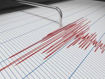
The Federal Emergency Management Agency (FEMA) places California in the “very high risk” category for earthquakes. In fact, California experiences the most frequent damaging earthquakes. However, Alaska experiences the greatest number of large earthquakes —most of which are located in uninhabited areas. The U.S. Geological Survey (USGS) is the leading agency that provides the public and policymakers with a clear understanding of natural hazards and provides comprehensive real-time earthquake monitoring.
The many fault systems running throughout the Los Angeles area can lead to earthquakes of all types and sizes. Many of the buildings have been retrofitted to withstand severe shaking, but you could still face many hazards and dangers.
- Southern California has about 10,000 earthquakes each year, though most are so small that they are never felt. (See: Recent LA Area Earthquakes)
- The USGS has published probability studies ranking the risk of the Los Angeles area having a major earthquake within 30 years (See: Major LA/SF Earthquake Probabilities)
- Large earthquakes create an aftershock sequence that can produce additional earthquakes for many months.
- Earthquakes can occur in cold, hot, rainy or dry weather; there is no such thing as “earthquake weather.”
- The San Andreas Fault zone stretches for 800 miles.
- Most earthquakes occur less than 50 miles below the Earth’s surface.
- Only four states - Florida, Iowa, North Dakota and Wisconsin - have not had earthquakes in the past 30 years.
Fire
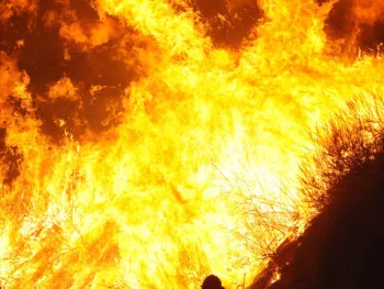
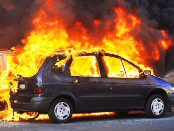
Fire is extremely powerful. In less than 30 seconds, small flames can race out of control, with temperatures reaching 600 degrees. The heat and poisonous gases from fires can be more deadly than the flames. Here in the Los Angeles area, wildfires, as well as residential or structural fires, are part of our everyday lives. That’s why it’s important to have a familiar plan, in case a fire should occur.
Residential fires are the third-leading cause of accidental death in the home, with yearly property losses reaching billions of dollars. Cooking, careless smoking, arson and faulty heating are often the cause of fires in the home. Many fire-related deaths and damages are avoidable with a proper smoke alarm system or residential sprinklers. Check the smoke alarms in your home every few months to make sure they are working properly.
One of the most important functions for the Los Angeles Fire Department (LAFD) is fire prevention. This includes both enforcement and education programs. LAFD inspectors work with homeowners and business executives to ensure that the LAFD Fire Code is followed. These programs have a proven track record relative to reducing the losses from fire.
Unpredictable wind conditions in Los Angeles can cause dense brush and dry hillsides and canyons. These areas are prone to bursting quickly into flames, starting deadly wildfires that are also known as brush fires. These fires can move at incredible speeds and their heat can quickly rise to thousands of degrees. One of the best ways to keep these fires a safe distance from your home is to make sure that nearby brush is cleared away, according to city and county regulations. All homes should be equipped with properly maintained smoke detectors and a fire extinguisher that you have been trained to use.
- Each year, fire kills more Americans than all other natural disasters combined.
- Careless smoking is the leading cause of fire-related deaths.
- Cooking is the major cause of home fires in the U.S.
- About 2 million fires are reported each year, though thousands more go unreported.
- Wildfires are most common in the summer, fall and during droughts when branches, leaves and other materials dry out, leaving them susceptible to eerily catching fire.
We urge everyone to follow "Ready. Set. Go!" recommendations from the LAFD, to be packed with some essentials and documents in case evacuations are ordered. Put the bag in your vehicle and back into your driveway, so you're "READY" Then, if you receive the order to "GO!", everything is "Set" for a quick escape.
The geography, weather patterns and number of Wildland Urban Interface communities in California make it a state particularly threatened by devastating wildfire. As catastrophic wildfires continue to increase each year in California, make sure to protect yourself and your family – plan, prepare and stay aware. Property owners and residents in areas most at risk are encouraged to visit Ready for Wildfire.
Also, see the regularly updated Active Fires of Interest map.
Tsunami
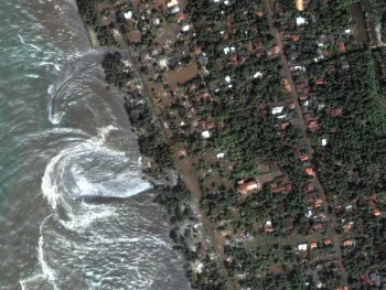
Tsunamis (soo-ná-mees) are also known as seismic sea waves and sometimes mistakenly called “tidal waves." They are a series of enormous waves created by underwater disturbances such as earthquakes, landslides, volcanic eruptions, or a large meteorite. A tsunami can move hundreds of miles per hour in the open ocean and smash into land with waves towering 100 feet high or more. Those that strike the Pacific Ocean Basin are most commonly caused by large earthquakes. Drowning is the most common cause of death associated with a tsunami. Though tsunamis are rare in our region, they can be deadly. The National Oceanic and Atmospheric Administration reports that 42 have reached LA County's coastline over the last 140 years. Recently, tsunami warnings were issued for coastline beaches here in 2009 after a Samoan earthquake, in 2010 following a Chilean earthquake, and following an earthquake in Japan in 2011.
- A tsunami includes a series of waves, sometimes increasing in size.
- Tsunamis can move at a very fast rate of speed.
- Sometimes a tsunami causes water near the shore to recede initially, exposing the ocean floor.
- Tsunami wave activity can move boats and other large debris hundreds of feet inland and demolish houses.
- Tsunami danger can last for several hours after the first wave hits.
- The 2004 Indian Ocean tsunami killed more than 150,000 people and left millions homeless.
To understand your risk and how to respond to a tsunami warning or evacuate, see: California Conservation
View and/or download current tsunami evacuation maps for LA City coastal areas:
Harbor Area Wilmington
Venice #1 Venice #2 West LA
Severe Weather and Flooding
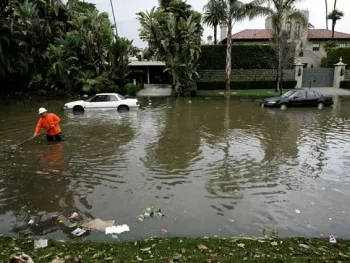
Los Angeles is a semi-desert area of mountains, canyons, ravines and vast basins. This can create problems when major thunderstorms, high winds and other bad weather strike. Flooding can quickly occur in the mountain passes and valleys, and mudslides are common on hillsides with very little vegetation. Southern California’s dry rivers, creek beds and deep slot canyons can be especially dangerous for those caught by a rapidly moving flash flood.
- Floods can occur at any time, though many happen after heavy spring rains, tropical storms and the melting of winter snow.
- Just six inches of rapidly moving flood water can knock a person down. It only takes two feet of water to float a large vehicle.
- Floods can be slow or fast rising but most develop over a period of days.
- Mudslides can easily travel faster than 10 miles per hour
- Flash floods can turn a calm landscape into a raging river just minutes.
- Most flash floods are caused by slow-moving thunderstorms, hurricanes or tropical storms, but also by dam or levee failures.
- Flash floods can move boulders, knock down bridges, and destroy buildings.
- Walls of water, often filled with debris, can reach up to 20 feet.
- If you receive a warning or are caught in a flash flood, move immediately to higher ground.
Extreme Heat
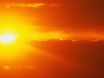
The blazing sun can become incredibly hot in Los Angeles, especially during summer days. Even indoors, temperatures can be just as uncomfortable if you don't have air conditioning or strong fans blowing cool air. For most of us, it’s unpleasant. For others, it can be deadly.
- Many hundreds of people die in the U.S. each year from weather-related heat, and many more die from health conditions worsened by rising temperatures.
- Those at greatest risk for heat-related illness include infants and small children, the elderly, people who are overweight and those who take certain medications.
- During hot weather, people should drink a lot of liquid – up to four 16-ounce glasses per hour if exercising in the heat.
- Drinking alcoholic beverages in unusually hot weather can also lead to heat-related illnesses.
Extreme Cold
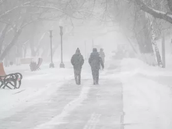
Heavy snowfall and extreme cold can immobilize an entire region. Even areas that normally experience mild winters can be hit with a major snowstorm or freezing temperatures. Winter storms can result in flooding, storm surge, closed highways, blocked roads and downed power lines. Weather of this nature can also cause hypothermia. While Southern California is usually warm and sunny, temperatures in our nearby mountains and even the deserts can drop dramatically. Without proper heating, some homes within the city can become dangerously cold in the winter, especially for the ill and elderly. When it comes to cold weather, below are some quick facts that will keep you informed and prepared:
- Extreme cold can cause the body’s temperature to lower dramatically, causing hypothermia and even death. Stay warm with extra clothing and blankets.
- Space heaters can cause fires during winter and should be kept at least three feet from drapes and furniture.
- Areas with the mildest winters normally have higher death rates from cold than those with colder winters, primarily because people do not prepare properly and they have poor information.
Landslides
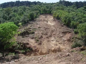
General erosion, heavy rains and other factors help to cause landslides. Most common during severe storms, earthquakes, volcanoes and wildfires, landslides can cause injury or even death. Debris and mud flows, (which are rivers of rock, earth and other debris saturated with water) can occur following heavy rain. They develop when water rapidly accumulates in the ground, during heavy rainfall or rapid snowmelt, changing the earth into a flowing river of mud or “slurry,” a thick fluid that often results from such conditions. They can flow rapidly, striking with little or no warning at avalanche speeds. The ground moves very quickly during a landslide. Even if it’s not directly underneath or above you, it can quickly affect any area close by. They also can travel several miles from their source, growing in size as they pick up trees, boulders, cars, and other materials.
- Landslides occur in all 50 states of the U.S., though the most common areas are those with mountainous terrain such as California.
- Landslides in this country result in costs of more than $4 billion annually.
- Between 25 and 50 people are killed by landslides in the U.S. each year.
- Landslides cause tremendous damage to the natural environment and also impact agricultural productivity.
- One of Southern California’s best-known landslides in recent history occurred on March 4, 1995, in La Conchita, California, along the Ventura County coast.
- Landslides can be activated by such human factors as deforestation (removal of trees and vegetation), poor irrigation, utility water leakage, mining activities, improper excavation of a slope, and hillside construction.
Hurricane
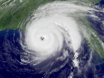
Hurricanes are powerful tropical storms that form in the southern Atlantic Ocean, Caribbean Sea, Gulf of Mexico and the eastern Pacific Ocean. They carry high winds and heavy rain that can be dangerous. Powered by heat from the sea, they are steered erratically by the easterly trade winds and the temperate westerly winds, as well as by their own energy. As they move ashore, they bring with them a storm surge of ocean water along the coastline, high winds, tornadoes, torrential rains and flooding. Many of these remain over the ocean with little or no impact on the continental United States. However, on average, about five hurricanes strike the United States coastline every three years. Of these five, two will be major hurricanes measuring a category 3 or higher (defined as having winds above 111 miles per hour) on the Saffir-Simpson Scale. These storms can end up costing our nation many millions, if not billions, of dollars in damages. It is important to follow the course of the storm to know whether to evacuate or remain inside to wait for it to pass. Here are a few facts you should know.
- Hurricanes feature severe winds of at least 74 miles per hour, usually accompanied by heavy rains. This powerful combination can damage buildings, trees and cars.
- A hurricane can extend for hundreds of miles across, from end to end.
- The official hurricane season runs from June 1 to Nov. 30, but these storms can occur at any time of the year.
- Then a hurricane hits land, its wind speed usually weakens, but the resulting storm surge can raise ocean levels by several feet.
- The worst hurricane in U.S. history roared across Galveston Island, TX., on September 8, 1900, killing 8,000 people.
Tornado
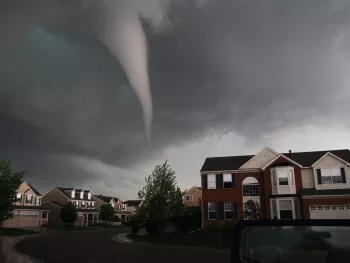
A tornado can destroy an entire neighborhood in a matter of seconds. Its spinning, funnel-shaped cloud extends up from the ground with winds that can flatten houses, commercial buildings and telephone lines. While tornados are most like to occur in southern states, they can occur in California. The last reported tornado to hit California occurred in 2004 in Inglewood, CA. It ripped off a roof, snapped trees and damaged vehicles.
- Whirling tornado winds can reach 300 miles per hour.
- The storm’s path of damage can extend one mile wide and up to 50 miles long.
- Tornados normally appear near the trailing edge of a thunderstorm, so it is not unusual to see clear blue skies behind a tornado.
- Tornados known as waterspouts can form over large bodies of water.
- Peak tornado season is from March through May in the southern states, and from late spring to early summer in the northern states.
Terrorism
Terrorism is the use of force or violence against persons or property in violation of the criminal laws of the United States. The purpose of these acts are typically intimidation, coercion or ransom. Terrorists often use threats to:
- Create fear among the public
- Try to convince citizens that government is powerless to prevent the violence
- Get immediate publicity for their causes
Acts of terrorism can manifest themselves in the form of assassinations, kidnappings, hijackings, bomb scares and bombings, cyber attacks (computer-based crimes), the use of chemical, biological, nuclear and radiological weapons and threats of terrorism itself.
Effective April 2011, the National Terrorism Advisory System (NTAS), replaced the color-coded Homeland Security Advisory System (HSAS). This new system will more effectively communicate information about terrorist threats by providing timely, detailed information to the public, government agencies, first responders, the private sector and airports and other transportation hubs.
The NTAS recognizes that Americans all share responsibility for the nation's security, and should always be aware of the heightened risk of a terrorist attack in the United States and what they should do.
The new alert system starts with the premise that the U.S. is at an elevated risk for attack. If intelligence officials determine that the threat rises above that baseline, the public will be notified that there is an elevated risk of attack using Facebook, Twitter, or through email subscriber alerts.
Register for NTAS Alerts and get more information about how this system operates. There you will also find:
- NTAS Public Guide
- NTAS Frequently Asked Questions
- Sample NTAS Alert
Cybercrime

Cybercrime is committed against network communications devices such as the Internet, a telephone line or mobile network. These hackers and spammers use computer viruses and other elaborate tactics that affect everything from personal computers to huge corporate and government network systems.
Cybercrime is a criminal activity committed via the Internet. This is a broad term that describes everything from electronic hacking to computer attacks that cause commercial sites to lose money. Cybercrimes can be basically divided into three major categories:
- Cybercrimes against persons: These include various crimes such as the transmission of child-pornography and the harassment of an individual with the use of a computer, such as via email. The trafficking, distribution, posting, and dissemination of obscene material including pornography and indecent exposure, constitutes one of the most important cybercrimes known today
- Cybercrimes against property: Crimes include computer vandalism and the transmission of harmful programs.
- Cybercrimes against the government: These are crimes committed by individuals and groups to threaten international governments and subsequently terrorize the citizens of a country. This crime manifests itself into terrorism when an individual breaks into a government or military-maintained website.
Public Health

Public health threats are events and disasters that spread in communities through the air, water supply and food chain and can also spread following human and animal contact. Public health threats are caused by disease outbreaks, natural disasters, hazardous accidents and terrorist attacks.
There are also many things in our environment that can be harmful such as chemicals, fumes, viruses, and bacteria. When these substances reach a threshold considered unsafe, they become urgent public health threats. In those cases, LA County Department of Public Health will issue an advisory instructing residents of steps and precautions they can take to protect their health and safety. Visit LA County Public Health.
Chemical Emergencies
Hazardous materials can be found in our homes, stores, hospitals and gas stations. They are routinely transported by trucks on local streets and highways. Consequently, there is always the possibility of an accident occurring. When accidents or small hazardous spills occur on our highways, these incidents can cause the public traffic delays. In the event of a major spill resulting in a chemical emergency, authorities will instruct you on the best course of action. Be sure to listen to media reports for instructions. When incidents occur in the home, seek medical attention as soon as possible.
The Los Angeles County Department of Public Health has a Poison Control Hotline at 1 (800) 222-1222 if you have specific questions about hazardous substances in the home.
Air Quality
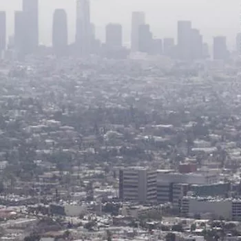
How do you judge how clean the air outside is? If you’re like many people, you check to see how clear the sky is, or what the “visibility” is like.
While visibility can tell you something about the levels of certain types of pollutants in the air, it doesn’t provide a complete picture of air quality. Certain types of pollutants like ozone and carbon monoxide have little effect on visibility; very high concentrations of these gases can be present even on the clearest day.
The U.S. Environmental Protection Agency (EPA) has created a better indicator of air quality, the Air Quality Index (AQI). This index is calculated based on the levels of five major pollutants in the air: ground-level ozone, particle pollution, carbon monoxide, nitrogen dioxide, and sulfur dioxide. Monitors at more than a thousand locations across the country record concentrations of these pollutants each day. These measurements are used to calculate AQI values for each individual pollutant as well as an overall daily AQI.
The Air Quality Index runs from 0 to 500: the larger the number, the greater the level of air pollution. To make it easier to use, the index is broken down into six general categories, each category corresponding to a different level of health concern. When the air quality index value is between 101 and 150, for example, air quality is considered to be “unhealthy for sensitive groups”, like people with heart or lung disease; when the value rises to above 200, air quality is considered “very unhealthy” or “hazardous” for the entire population. Check the AQI in your area at: AirNow
Groups that are unusually sensitive to air pollution include individuals with heart and lung disease, children and older adults.
Simply knowing what the air quality is like, doesn’t protect you against the harmful effects of air pollution. That’s why the U.S. EPA developed a set of recommendations for each of the individual pollutants. The precautions coincide with the six air quality categories. For example, when the AQI for ozone rises above 150, children and older adults as well as people with lung disease are cautioned to reduce prolonged or heavy exertion outdoors; when the AQI for sulfur dioxide rises above 200, children and people with heart or lung disease are encouraged to avoid outdoor exertion entirely. A complete set of recommendations can be found in the U.S. EPA’s publication: Air Quality Index Basics
AIR QUALITY FORECASTS/ADVISORIES
Current Air Quality, Forecasts and Advisories (South Coast Air Quality Management District)
L.A. County Public Health Advisories and Alerts
LINKS
American Lung Association
Air Pollution and Health (California Air Resources Board)
Office of Air and Radiation (U.S. Environmental Protection Agency)
South Coast Air Quality Management District